The 606 Trail (Bloomingdale Trail): Map, Access, Hours and What to Know
The 606 is a 2.7-mile elevated trail on the old Bloomingdale rail line. Where it starts and ends, hours, access, parks along it, and the planned extension.
The 606 is a 2.7-mile elevated park and trail, with the Bloomingdale Trail as its centerpiece2,1. It runs east to west from Ashland Avenue to Ridgeway Avenue on a former rail line3. The trail is open every day from 6 a.m. to 11 p.m.1.
- At a glance
- Length
- 2.7 miles, Ashland Ave to Ridgeway Ave2
- Hours
- Daily, 6 a.m. to 11 p.m.1
- Height
- About 20 feet above street level3
- Surface
- Concrete with a blue rubberized running path on each side2
- Opened
- June 6, 20152
On this page
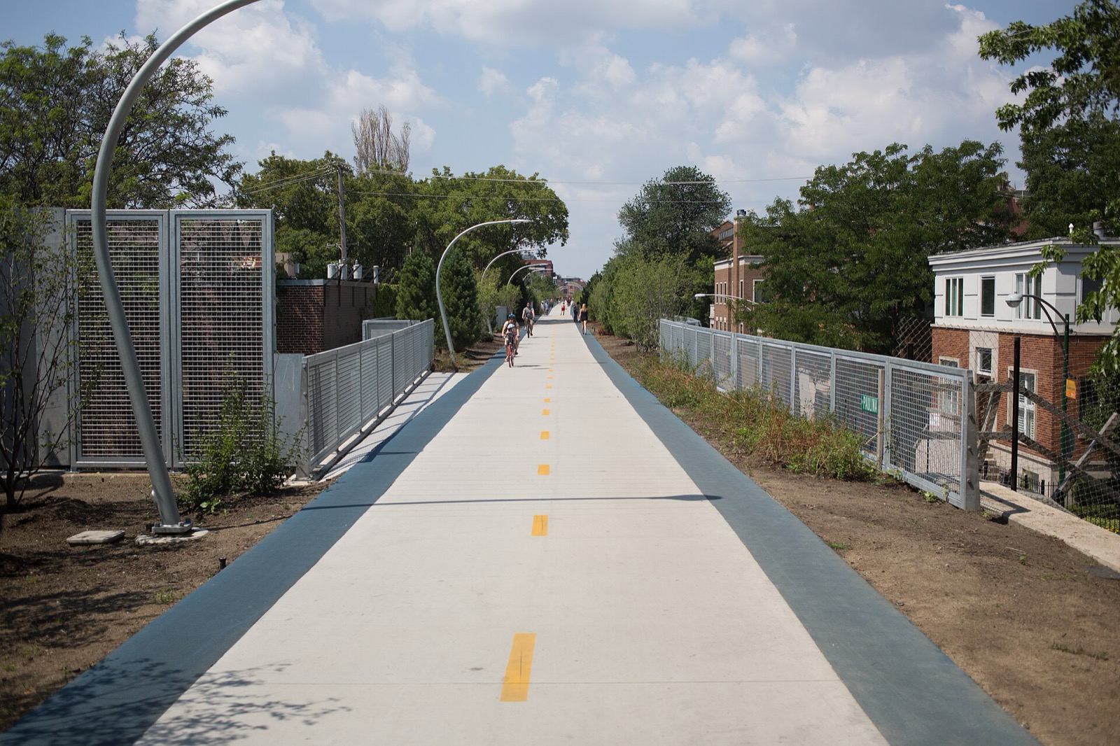
The 606 is a straight ribbon of trail raised about 20 feet above the Northwest Side street grid3. Browse the full list of Routes & Trails for the rest.
What it is
The 606 takes the old Bloomingdale rail line and makes it a park. The elevated Bloomingdale Trail is its centerpiece. It connects to four neighborhood parks at ground level, an observatory and art installations1. The trail runs about 20 feet above street level3.
The Bloomingdale Line was built in 18732. The line was raised roughly twenty feet in the 1910s, to reduce pedestrian deaths at grade crossings2. Steel-reinforced concrete embankment walls line the corridor, with 38 viaducts2. After more than a century of service, the tracks fell into disuse by the mid-1990s3.
The idea for The 606 was officially presented in 2003 as part of a city initiative for more green space on the Northwest Side3. The City of Chicago bought the right-of-way from Canadian Pacific in January 20132. The park opened on June 6, 20152.
The name
“The 606” is a nickname drawn from the numbers common to Chicago zip codes. The trail spans 60647 and 606223. The trail itself is officially the Bloomingdale Trail3.
Start, end and access
The trail runs east to west, 2.7 miles in all2. The east end is on Ashland Avenue in Bucktown and Wicker Park. The west end is on Ridgeway Avenue, near the edge of Humboldt Park and Hermosa3.
Two useful exits:
| Exit | What is there |
|---|---|
| Damen Avenue | Walk to Six Corners, the center of Wicker Park3 |
| Humboldt Overlook | A short walk to Humboldt Park and its lagoons3 |
Hours and surface
The 606 park and trail system is open every day from 6 a.m. to 11 p.m.1. The surface is concrete, with a blue rubberized running path on each side2. Cyclists, walkers and runners share it during park hours2. E-scooters are not allowed3.
What you pass
Four street-level parks connect to the trail: Walsh Park, Churchill Park, Park 567 and Julia de Burgos Park3. On the trail itself are the Damen Arts Plaza, the Humboldt Overlook, the Milwaukee Bridge, the St. Louis Overlook and the Exelon Observatory at Ridgeway2. The observatory sits at the west end, where a spiraling path leads to a platform marking the winter and summer solstices3. The Humboldt Overlook is a lookout point with plenty of seating above the tree-lined boulevard3. The Damen Arts Plaza has bleacher seating and rotating large-scale sculpture3. More than one million people use The 606 each year3.
Renting a bike nearby
Bikes are available from Divvy stations near the trail3. For a longer route that ties the trail to neighborhood streets, see the Bucktown and Wicker Park bike ride. To connect to the lake, the Lakefront Trail guide covers the next step.
The extension
The Chicago Department of Transportation unveiled a plan in August 2023 to extend the trail east of Ashland Avenue. It would cross over Ashland Avenue, go under the Kennedy Expressway and the Metra rail corridor, and reach Elston Avenue2. The extension is planned for late 20272.
Events
Friends of the Bloomingdale Trail run a yearly trail run, with the 2024 edition on September 284. Public art, seasonal plantings and soundwalks fill the calendar through the year4.
Read next
Bucktown and Wicker Park Bike Ride: Milwaukee Avenue and the 606
Ride Bucktown and Wicker Park: the 606 elevated trail, the Milwaukee Avenue protected-lane project, and Six Corners.
routesChicago Lakefront Trail: Length, Access, Sights and Where to Start
The Lakefront Trail runs 18 miles along Lake Michigan from Ardmore to 71st Street. Where to start, what you pass, how long it takes, and current repairs.
routesBest Bike Rides in Chicago: Trails Ranked by Type of Ride
The best bike rides in Chicago: the Lakefront Trail, The 606, North Branch Trail, North Shore Channel and the forest preserves, with lengths and surfaces.
Questions people ask
Where does The 606 trail begin and end?
The east end is on Ashland Avenue in Bucktown and Wicker Park3. The west end is on Ridgeway Avenue, near the edge of Humboldt Park and Hermosa3. The trail runs 2.7 miles between them2.
Why is The 606 called that?
The name is a nickname from the numbers common to Chicago zip codes. The trail spans 60647 and 606223. Its official name is the Bloomingdale Trail3.
What are the hours of The 606?
The 606 park and trail system is open every day from 6 a.m. to 11 p.m.1. Friends of the Bloomingdale Trail list the same hours, 6am to 11pm daily4.
Sources
- The 606GOV
Chicago Park District · chicagoparkdistrict.com · checked 2026-10-19 - Bloomingdale TrailREFERENCE
Wikipedia · en.wikipedia.org · checked 2026-10-19 - Explore The 606 elevated park and trail in Chicago
Choose Chicago · choosechicago.com · checked 2026-10-19 - Bloomingdale Trail - Heart of the 606NONPROFIT
Friends of the Bloomingdale Trail · bloomingdaletrail.org · checked 2026-10-19
Photo credits (1)
- Victor Grigas / Wikimedia Commons · CC BY-SA 4.0 · source

Laws are quoted from Illinois statute and the Chicago Municipal Code; prices from each operator on the date shown. Editorial policy · Corrections.